
After the major Alpine snowfalls in November, it’s been an exceptionally dry December and start to 2017 in the Alps, and currently there’s poor snow cover and quite a low avalanche risk (link). Don’t be lulled into false sense of security, as all the forecasts seem to agree that winter is arriving in a big way next week!
Now is the time to get prepared, and this season the online mapping makes it easier than ever before to assess the risk of avalanche on specific slopes, as a factor of their angle. While planning a ski tour, approach to a climb, off piste descent, or snowshoe trek, you can now look at free online Alpine mapping, with overlays to indicate slopes of particular angles. This blog covers some of the most accessible free mapping, and shows how easy it is for you to plan a route this winter, to minimise avalanche risks.
EXAMPLE 1 – Vallorcine valley and Refuge de Loriaz
Below are two mapping screenshots of the Loriaz mountains, on the Franco-Swiss border, showing shading overlays of slopes greater than 30 degrees, where avalanches are more likely. This region is a very popular objective for ski touring and snowshoeing.

IGN Carte des Pentes; link
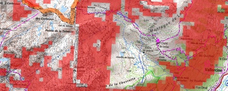
SkiTrack.fr Notice Pentes >30; link
As you’ll see from the screenshots above, the information is displayed slightly differently on the two applications. The IGN mapping colour codes the slopes as yellow 30° to 35°, orange 35° to 40°, red 40° to 45° and violet for slopes steeper than 45°. This data is very detailed, but as with the European avalanche scale where most people are caught in avalanches when the risk is relatively low, there’s perhaps a risk of a false sense of security given when crossing slopes that are ‘only’ yellow.
The overlays on SkiTrack maps are more basic, but there’s no risk of any visual feeling of security, and it encourages greater attention to local regional variations. An added advantage of the SkiTrack website is that it easily allows you to toggle the base maps between Google satellite, Open Streetmap, IGN, SwissTopo, and Spanish IDEE. It also allows you to select the slope markings of your choice to; IGN 75, Aster 30, or IGN slopes, so you can opt for a style that you prefer, and easily switch between them all.
EXAMPLE 2 – Grand Saint Bernard and Mont Mort
This region is on the Swiss-Italian border, and the Hospice du Grand Saint Bernard is a very popular objective for skiers and snowshoeing in the winter months. The two maps below are screenshots from the SwissTopo website, with two key overlays.
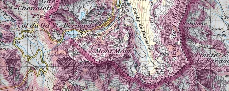
SwissTopo – overlay showing all slopes in one colour which are above 30°

SwissTopo – overlay showing classification (grading) of all slopes over 30°
As with all things Swiss, the key is in the detail, and the accuracy of these overlays is incredible, down to a 10m grid, so you can really zoom into an area to check the angles.
Of course avalanche planning both beforehand, and when on the mountain, is far more than assessing slope angles. If only it were so easy! Having said this, if the avalanche risk is on the lower end of the scale (e.g. 1 or 2 out of 5), and you avoid slopes specifically identified in the avalanche forecast, and all slopes identified as over 30° in the online mapping overlays, you’d be very unlucky to be caught in an avalanche.
As with all mountain activities, there’s no such thing as no risk, and it’s about managing risk. These online mapping tools are free and easy to use, so why wouldn’t you check before you go? Obviously experienced navigators, guides, and outdoor instructors, can all work out slope angles from the contours on the map alone, but these online maps make it easy for everyone to check, and are highly welcomed.
COURSES
If you are interested in learning more, we invite you to look at our avalanche training days, which are held both in the UK Lake District and the Alps;
1) UK avalanche training day in the Lake District; link
2) Alpine avalanche day in Chamonix or Courmayeur; link
LINKS
France, IGN Portail, Carte des Pentes; link
Swiss Topo, Carte des Pentes; link
Ski Track, France, Notice Pentes; link
Haute Savoie, avalanche forecast; link
